

In the afternoon of April 13 of 1.918, Luis Cenobio Candelaria, an Argentinian pilot achieved the milestone of flying over the Andes for the very first time. With his wooden made monoplane Morane Saulnier Parasol, mounting an 80 HP piston engine, had to face strong winds. At that time, the results of these winds could cause on an aircraft flying over the Andes were unknown. Mountain wave is the result of these winds.
Year 2.019. Flight Madrid – Santiago de Chile.
We are in the briefing area in order to prepare our flight from Madrid to Santiago de Chile. Our airplane is an A340-600X and we have an expected take of weight close to 373 tonnes. Quite different to Candelaria’s Morane. During briefing, Captain makes a special question which is not made in other flights: “How is it over the Andes?”
The Andes is very large mountain range which extends along South American continent. On the occidental side of the continent besides Pacific Ocean. It’s 8.500 km long with an average altitude between 3.000 and 4.000 metres above sea level. The Aconcagua is the highest peak with nearly 7.000 metres. This big natural wall causes very often turbulences, severe in certain occasions due to a phenomenon called Mountain wave. Specially in the area between Chile and Argentina. Let’s see what’s the mountain wave is and how to prevent it.
Today looks quite smooth. Wind, temperature, pressure difference… But, let’s go back the beginning. Why is this data necessary? What is the mountain wave? Why should we worry about?
Mountain wave.
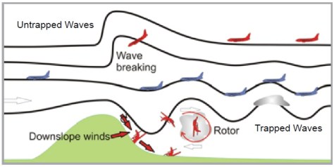
Mountain wave are great air oscillations on the leeward side of a high elevation as a result of horizontal air mass movement disturbance over the high terrain elevation. To make a picture of the size of this phenomenon, these disturbances can reach hundreds of kilometres horizontally and to reach tropopause vertically. Mountain wave is associated with turbulence, from light to severe. In other words, when winds blow over an elevation creates oscillations on the other side of the elevation. When oscillations are larger, break off and create areas of turbulence. That’s is the reason why we should know how to prevent it.

Some factors are necessary for a mountain wave to exists. Already mentioned before, it’s the most contributor factor of all, the existence of perpendicular wind to the mountain range. Depending on size of the elevation, from 15 to 25 knots is sufficient.
It’s also necessary a certain atmospheric stability. Stability forces the air to climb on the windward side of the mountain and it’s also forced to descend on the leeward side. Because of its stability, when it’s “pushed” downward creates a wave on its way. If this air reaches a certain speed, it can break away from the up and down air waves having as result the “rotors”.
Rotors are kind of circular air movement which are the main cause of severe and extreme turbulence. A very famous case was when a B52 of U.S. Air Force was caught close to the Rocky Mountains, in the area of Kansas and lost its vertical stabiliser. Miraculously, they achieved an emergency landing with no further consequences.

Visible signs.
Mountain wave is not always visible. If humidity is enough, clear signs of mountain wave like clouds, makes this possible. When there isn’t, there are diagram to prevent it like Graphic of Harrison in the Andes, so the turbulence could be foreseen.
In first case, when analysing wind chart in different levels, it’s easy to see if there is a perpendicular wind to a mountain range and its intensity, so we can expect some turbulence. If the wind speed it’s moderate and there is enough atmosphere stability, the clouds shape “stylizes”, turning into the well known as lenticular clouds. It’s very usual to find temperature inversion in this area. In fact, we can see sometimes some stationary clouds on top of the others due to different wind layers. These are a very representative type of clouds, and they’re located on the crest of waves. They can reach 9 kilometres high easily.
In some occasions, on the windward side the air is forced to climb the slope of the mountains which condenses, creating cloudiness up to the crest. Nimbostratus and cumulonimbus are the most typical type of clouds, covering totally or partially the lenticular clouds in the lower layers. It’s likely to find icing accretion at these levels before reaching to leeside.
Once on the leeside, the air is forced downward the slope and clouds dispel, creating the Föehn wall or cloud-cascade. However, in the upside of the air wave, a little further away from the mountain, air condenses again creating little cumulus or cirrus type clouds. As mentioned before, if wind is strong enough wave brakes away from the rest of waves and creates rotors clouds. This rotor cloud looks like a twisting movement cloud, causing sensation of circular movement by appearing and disappearing. This type of cloud is Cirrus and, you’d better keep away from them, sinking air prevails over lifts.

Amongst documented accidents due to this phenomenon, took place in Spain in 1.953. A Bristol 170 Freighter Mk21 (EC-AEG) of Spanish airline Aviaco was flying from Bilbao and Madrid when they encountered mountain wave and crashed. In an aviation meteorology book, authors Manuel Ledesma and Gabriel Baleriola, published a letter fragment written by Captain Cañete about weather conditions found flying before, and during accident. Captain describes in great details all weather phenomenon found, relating to mountain wave concepts clearly with no doubts at all.
The Andes mountain range.
After Himalaya, Andes have the highest peaks in the world. To fly over them is a daily challenge.
To fly over Andes to/from Santiago de Chile from the Argentinian side is the most difficult one because all mentioned factors affecting are more significant, specially between Mendoza and Santiago. In fact, Aconcagua, the highest peak is in this area. Prevailing winds, coming from west blow on Andes perpendicularly and increases probability of turbulence.
Due to these local peculiarities, some studies helped to develop procedures to anticipate and to avoid mountain wave. Graphic of Harrison is one of them.
This is a graphic used to obtain a reference of turbulence intensity comparing the pressure difference (abscissa axis) between two sides of mountain range, Santiago de Chile and Mendoza, and wind at 18.000 feet (ordinate axis) in Juan Fernández archipelago located 450 NM west of Santiago de Chile. This is, the greater pressure exists on the leeward side, and the lower in windward side, it’s likely to find mountain wave. Besides this, the stronger wind will increase turbulence factor. The result, obtained combining two previous factors in the graphic, gives three different colours areas. Each colour means an expected different turbulence intensity.

Another way, quicker but less accurate, to determine turbulence, is to compare temperatures and QNH (barometric pressure) between Santiago de Chile and Mendoza. If there was a difference of 5º C or more, higher in Mendoza than in Santiago, or if barometric pressure would be higher in between 8 to 12 hPa in Santiago than in Mendoza, we would have a higher probability to find turbulence. It’s more simple and quicker.
As a summary, studies which gave birth the Graphic of Harrison, there are some factor which when concur at the same time raise probability of turbulence in Andes:
- Wind direction at FL180 in between 280º and 320º;
- QNH higher in Mendoza than in Santiago;
- Cold occlusion in Juan Fernández archipelago. Specially in austral winter;
- Lower temperature in Santiago than in Mendoza.
There is no doubt a pilot reports are necessary and, in this case is part of the procedure when overflying certain waypoints. When overflying from east to west, a full report to Chilean ATC is given with next information: Flight level, sport wind, temperature and level of turbulence found. This data is gathered to make predictive reports of mountain wave. Airplanes are, sometimes, mobile meteorology stations capable of giving very useful atmospheric data.
There are four main routes to fly over the Andes. The highest probability to find severe turbulence is in the area of waypoint UMKAL, south of Aconcagua. In this case, the better option is to divert south, where the terrain is lower, overflying waypoint ANKON. Other waypoints are MIBAS and ASIMO, north of UMKAL, where conditions are likely to be more favourable.
If the route comes from north, it’s more convenient to overfly the Andes a little more up north instead to fly south to ANKON. Flying parallel to Andes on the “bad” sector would expose your aircraft to turbulence associated with mountain wave.

How to avoid turbulence?
In the previous point, we mentioned mountain wave created in Andes between Mendoza and Santiago de Chile. However, there are plenty of mountain waves around the world in bigger or lesser scale.
If there would have been reported moderate to severe turbulence, or just some of the previous mentioned visual signs would have been sighted, to scape is a very healthy procedure. Turn 180º or choose an alternate route are the best solutions ever.
By the contrary, if you’re surprised by turbulence, or after a risk analysis you have decided to continue, speed will be your best friend. To keep turbulence speed according to your airplane flight manual, is the best safeguard to keep the structural integrity to high loads caused by turbulence.
Altitude is your ally. Is mandatory to keep at altitudes above the highest peak of mountains. As we mentioned before, rotor clouds are the most dangerous and found at a lower altitude than crests. However, if altitude is too high, the aircraft could encounter high altitude waves with very dangerous lifts and sinks. It is then recommended to fly at altitudes around 25.000 feet which is the safest zone. Even though, lifts and sinks you’d be flying through, suggest keeping thrust power above flight idle to use it in case was necessary. Some flight manuals recommend to disconnect Autothrust/Autotrottle because in certain circumstances system time reaction is longer than required.
In light general aviation, besides precautions that have to be taken when flying in high terrain, in the mountain wave case, there is a rule of thumb which helps to determine the safest distance from the mountain to fly away from mountain wave when flying on the leeward side. This is, the elevation of mountain in feet multiplied by wind speed in knots. For example, if the mountain is 1.000 ft high, and wind speed is 20 kt., 20.000 ft (around 6 km) will be the minimum safest horizontal distance.
Carrying passengers means a special briefing to cabin crew is needed when turbulence from mountain wave is expected. The cabin must be secured in advance to avoid unexpected movement of objects which may cause personal injuries. Explaining to passengers the reason of “fasten seatbelts” sign is crucial. We know, some passengers consider excessive our indications of seatbelts use, but we also know that consequences are very serious.
Ah! To report ATC is not only necessary but MANDATORY, by the way.
In 2.009, we were flying between cities of Bucharest (Romania) and Sofia (Bulgaria) on a Bae146-200QT. In spite it was a cargo flight, typically flown night, we were flying just after sunrise and we could observe some lenticular clouds scattered over the Balkan Mountains, north of Sofia. During descent we’re having some tailwind and winds at Sofia were westerly. We were just passing 25.000 feet and we complicit gazed each other when we realised flight would be a little bumpy over the mountain range. Automatically we ask ATC to stop descending and to reduce speed to our turbulence’s one… Some moderate jerks later on, gave us the impression we took the correct measures. Manolo and I, after more than a decade later, we still remember what happened. With no further consequences we normally landed minutes later in Sofia, by the way.
It was not all bad, after all.
Flying over mountains or high terrain is the target of some air sports such as hang-gliders or gliders.

The wind which helps to create the mountain waves on the leeward side, is the same wind which creates the right conditions to practice this kind of air sports. Near Santiago de Chile there’s an aerodrome where the gliders take the advantage of the westerly winds when blowing towards the mountain range. In Spain, in Piedrahita, Ages or Fuentemilanos; Larange or Lachens in France; Monte Cucco in Italy, are clear examples where to find this addictive air sports.